








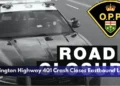
The transit operations grids, municipal engineering panels, and community safety dispatchers within the Durham Region are deploying emergency neighborhood traffic management plans. Tracked under provincial transit corridor overhauls, municipal road network management, and municipal-provincial governance friction portfolios on Friday, July 17, 2026, transportation planning reporters finalized the infrastructure brief ‘A very stupid decision’: Park Road South joins the list of Oshawa roads closed by the province. A dual-front provincial infrastructure push—combining the Ministry of Transportation’s (MTO) massive expansion of Highway 401 to 10 lanes with Metrolinx’s long-term Lakeshore East GO Transit rail expansion—has systematically severed four of the city’s primary north-south transit pipelines, effectively placing south Oshawa neighborhoods under an operational traffic siege.
Municipal representatives emphasize that because the province accelerated the closure timeline by a full year without updating local detour grids, cut-through traffic is invading quiet residential side streets, resulting in collisions on day one.

The Multi-Street Gridlock Blueprint and Fall 2027 Timelines
The concurrent execution of major structural bridge replacements and rail widening has created a severe barrier across the southern tier of the city:


-
The Park Road South Lockout: The newest closure completely blocks Park Road South, from Bloor Street to College Avenue. The route will remain entirely impassable to regular motorist traffic until at least the fall of 2027.
-
The Four-Arterial Severance: Park Road South now joins a heavily constrained cluster of major north-south conduits experiencing long-term provincial closures, including Cubert Street, Simcoe Street South, and Wilson Road South. No baseline grid relief is projected until Wilson Road’s scheduled reopening in the late spring of 2027.
-
The Transit Expansion Catalyst: The prolonged grid blockages are required to facilitate the expansion of the Lakeshore East rail corridor, a project designed to bring two brand-new GO Transit train stations to south Oshawa, ultimately providing the city with three active GO hubs by the 2030s.
-
The Shifted Schedule Grievance: Local ward representatives confirmed the Park Road closure was originally promised to hold until 2027 after Wilson Road reopened. Instead, the province advanced the project by 12 months to run concurrently with the neighboring Cubert Street intervention.
Analyzing the South Oshawa Road Closure Grid and Commuter Impact Matrix
The massive scale of the overlapping provincial engineering zones has transformed the local street map into a series of highly congested detour loops.
| Closed North-South Arterial Axis | Target Reopening Projection | Underlying Provincial Construction Driver | Secondary Potential Risk Zones | Active Local Detour Bottlenecks & Hazards |
|
Park Road South (Bloor to College Ave) |
Fall 2027 • Advanced by 1 year |
• Highway 401 10-lane widening. • Lakeshore East rail expansion. |
• Harmony Road • Ritson Road • Bloor Street |
College Avenue Detour: High congestion; early single-vehicle crash reported against a retaining wall. |
| Wilson Road South |
Late Spring 2027 • Primary relief node |
Full bridge structural replacement over the rail corridor. | Main commercial and industrial delivery links. | Localized delays averaging an additional 25 minutes for cross-town drivers. |
| Simcoe Street South | Long-Term Closure | Complete sub-structure bridge expansion to accommodate wider rail ties. | Core north-south transit lines down to the waterfront. | Severe commercial vehicle rerouting and secondary corridor overload. |
| Cubert Street | Long-Term Closure | Parallel right-of-way grade adjustments for Metrolinx tracks. | Local residential access corridors. | Extreme local street pathing; creation of dense “spaghetti street” routing. |
The Municipal Protest and Inter-Agency Communication Directives
“This is what happens when you don’t co-ordinate your traffic patterns with the people who actually know how this traffic works. They’re making decisions that look right to them on paper, but make no sense for the community,” stated Oshawa Ward 5 Councillor Brian Nicholson, fiercely criticizing the lack of institutional coordination between Metrolinx and the MTO. Nicholson highlighted that municipal planners are frequently excluded from active scheduling decisions, forcing city hall to learn about incoming street freezes directly from frustrated neighborhood phone calls rather than official provincial briefs. While both Metrolinx and the MTO defended their workflows, claiming they collaborate closely with local staff to minimize community friction, the immediate reality for south Oshawa commuters involves severe cut-through volumes and complex detours that demand maximum driving caution.
The Ontario Ministry of Transportation (MTO) Southwest Region, the Metrolinx Capital Infrastructure Team, the City of Oshawa Traffic Engineering Division, and the DRPS Traffic Safety Unit handle ongoing construction corridor management, detour sign deployment, and neighborhood speed enforcement.
Oshawa drivers, commercial logistics operators, and local residents looking to view the live interactive road closure map, submit complaints regarding neighborhood detour speeds, or track structural completion updates for the Wilson Road bridge can find the tools online through the central City of Oshawa portal via the designated traffic dashboard links, review regional transit frameworks through the Metrolinx project hub, or monitor community construction updates through the Oshawa This Week news stream.